Trooper Traverse – Route Details
Accuracy not guaranteed — for reference only — create your own GPS and map route using this information as a base. I’ve done the route twice as a ski trip as well as spending many other days on portions of the route over past years. We closely followed the trooper’s journey, but many variations are possible.
Download GPS file that’ll display route in Google Earth or wherever…
The best ski mountaineering routes take spectacular terrain, have a foundation of known history, are easy to access, and perhaps most importantly, are safely repeatable. The Trooper Traverse has every one of these qualifications. I highly recommend repeating it.
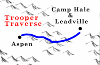
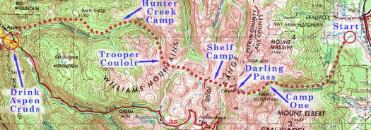
Trooper Traverse overview map, Colorado.
Be warned, however, that this is an advanced level ski route, with no huts, taking extreme avalanche terrain. Navigation is difficult. Following the exact soldier’s route may require previous experience with parts of the trail, especially the Hunter Creek section. Consider hiring a guide familiar with the area. Several groups have tried the route and failed because of inexperience with route finding, steep snow, and lack of local knowledge.
I only recommend tackling this route during the spring snow season, when the snow is more compacted and avalanche danger easier to predict and avoid. This season lasts from some time in early May, sometimes later April, through the first part of June. Early May is recommended as you’ll have more snow for the lower elevation parts of the trip. But don’t go until the spring snow season has begun.
Roads and Trailheads:
After snow melt-off begins in the spring, the Halfmoon Road (dirt, medium clearance 2-wheel-drive) leads deep into the heart of the Northern Sawatch Mountains on the Leadville side of the range.
To reach the Halfmoon Road, start on Harrison Avenue (Highway 24) in old-town Leadville. Drive S out of Leadville 3.7 miles on Highway 24 to the Fish Hatchery Road (State Road 300). Take a right (W) on to the Hatchery Road, drive .8 mile, and take a left turn onto County Road 11. Drive 1.1 mile S on Road 11 to the actual Halfmoon Road (good sign). Take a right on Halfmoon Road (enjoy a good view of Mount Massive straight ahead) and drive 4.4 miles to Halfmoon Campground. (Don’t confuse this with Halfmoon Campground near Mount of the Holy Cross). From Halfmoon Campground, continue about 2 miles and look for Mount Elbert Trailhead’s obvious parking and signboards on the left (S) side of road. Continue .3 miles and look for signboards to your right indicating the the Mount Massive Trailhead. Halfmoon Campground is huge, so the mileages referenced from the Campground are approximations. The trailheads are obvious.
From the Mount Massive Trailhead continue up the main drainage and road 1.9 miles to an obvious fork (possibly marked with a Forest Service road stake with the number “110.3A”). This is the South Halfmoon Creek Trailhead (10,330’) — but is not your route. Do not take the left fork. Again, continue up the road that follows the main drainage with the creek to your left. At .6 miles from South Halfmoon Creek you’ll see signs to your right indicating the North Halfmoon Creek trail. Do not take this trail. Again, stay on the road in the main drainage. Continue a few hundred yards up the road. You’ll notice the road bears left and crosses the creek. Take this important creek crossing that leads you into the main Halfmoon Creek drainage and Champion Mill area.
During heavy snow years you may find a snowbridge for the creek crossing. If not, wade it in your boot shells without liners so as not to risk injuring your feet. A cabin used to be located to the right about 100 feet past the creek crossing, and research indicates the troopers may have stayed in this cabin during their first night out. Sadly, the cabin burnt down in 2004. Continue up the drainage to the Champion Mill area and Darling Pass (see route description below).
Snow closure varies on the Halfmoon Road. Early winter snow closure can be as far as Halfmoon Campground, with the road again open to Halfmoon Campground by mid May. Winter and early spring closure may be several miles from Halfmoon Campground and trailheads, frequently just after the turn from County Road 11. Melt-out is complete by mid or late June. Mining activity or cabin owners can change this. The Halfmoon Road is a designated multiple use trail shared in winter by skiers and snowmobilers. Check road conditions with the Forest Service in Leadville.
On the Aspen Side things are even more convoluted. If you’re planning on hiking into Aspen (recommended way to finish) you’ll figure it out. Here are directions for Aspen and Hunter Creek trailhead access if you wimp out and someone is picking you up (no cruds for you). Stay in cell phone contact with your pickup person, as this area is incredibly confusing.
To reach the Hunter Creek trailheads (note the plural, this is a confusing area), start in the town of Aspen. Follow Main Street in Aspen to Mill Street (the stoplight near the center of town, next to the Hotel Jerome). Turn N on Mill and drive a short distance down a hill, then across a bridge over the Roaring Fork River (.25 miles). Bear left after the bridge and follow the Red Mountain Road 1.2 miles to its second switchback. Just before the switchback, turn right and downhill on the Hunter Creek Road. Drive approximately .5 miles on Hunter Creek Road, then take a hard left on an unpaved driveway that leads up past a water tank 300 feet to a parking area. The actual trailhead is farther up the mountain (see below), but this is the lesser regulated overnight parking and is a good pickup for the Trooper Traverse.
For the highest elevation “Upper Hunter Creek Parking Area” follow Hunter Creek Road up Red Mountain and go NE through the stone pillars continuing up Red Mountain Road for approximately 6/10th of a mile to a 3-way intersection. Take a very hard tight turn, and continue E 1/10th of a mile through two sharp switchbacks. Continue to the well signed parking area and respect private property. If you can find this trailhead, it’s the best pickup for the Trooper Traverse.
Trooper Traverse ski route description:
Day 1: Start on Halfmoon Road near Leadville, Colorado (see road details above). Drive to snow closure, usually just a few miles off the paved Fish Hatchery Road but you may be able to drive much farther (rough, high clearance mandatory, four-wheel-drive recommended). Hike a long slog up the road to camp in the head of the Halfmoon Drainage, at the base of French Mountain. Where you camp here is not critical. If you feel strong camp higher, near the old mining structures of Champion Mill. See the road description above for exact route up Halfmoon drain.
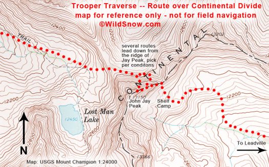
Day 2: This is your first day in the alpine. Climb over Darling Pass, drop into the head of North Fork Lake Creek, and continue West to camp on a rock shelf perched just under the Continental Divide near what I like to call John Jay Peak. If weather dictates, camp lower.
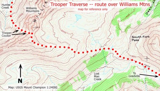
Day 3: The soldiers took a tricky route over the Divide, to avoid the steeper pass that forms a direct link to the head of Lost Man Creek. I suggest using the soldiers route, to honor them and spice up the route finding a bit. Climb part way up John Jay Peak, then cross the Divide via the “Soldiers Variation,” drop into Lost Man Creek, and ski a long, low angled run to the South Fork Pass area and base of Williams Mountains. Climb a broad avalanche safe ridge to a bump on the Williams ridge (good name for this is “Trooper Peak”), south of the big jagged peak that defines the Williams. From Trooper Peak, head N along the ridge for a few hundred feet, then ski westerly down the Trooper Couloir into Hunter Creek. Head down the Hunter Creek Valley and camp in the timber. (Cell service in upper Hunter Creek may be spotty or non existent.)
Day 4: Continue down Hunter Creek. Eventually leave Hunter Creek by heading north through Hunter Flats, then head west again on old logging roads, eventually intersecting the main roads leading into Aspen. You’ll pass south of the 10th Mountain Hut Association McNamara Hut, which can be used by reservation when it’s open (it closes in spring). For the last part of the route the soldiers used the old logging road perched high on the north side of the Hunter Creek valley. Cell Phone for a taxi or friend pick-up at the top of Red Mountain (a high-end residential area), or walk down into Aspen as the soldiers did. Make a beeline for the Hotel Jerome, and quaff Aspen Cruds.
Colorado USGS Maps required to cover route, from east to west: Mount Massive; Mount Champion; Thimble Rock; Aspen.
